Kurukulla

Kurukulla
Kurukulla, anchored at James Bond Island, Thailand

Saturday, 14 September 2019

Tahiti to Fiji via the Society Islands (Moorea, Huahine, Raiatea, Taha'a and Bora Bora), Suwarrow (Cook Islands), US Samoa and Tonga.


The "Cascade d'Eau" at Tiarei, Tahiti
To make the best of our time in Tahiti we hired a car for a day to tour the island. The main road runs round the foreshore of Tahiti Nui (the main part of the island) and partway down the east and west coasts of Tahiti Iti (the smaller part of the island; the two parts are joined at the hip so to speak!). The whole trip took five hours including a lunch stop and was unremarkable in many respects. The excellent condition of the roads took us by surprise after our experiences elsewhere. The architecture was unimpressive; however, the scenery was amazing with the verdant hill sides and numerous waterfalls, greatly outpacing the one in Fatu Hiva!
A problem in every island, not just Tahiti
The down side is that this island; in company with most others, both here and in the Caribbean; has a major problem with abandoned derelict cars; there needs to be a system where final scrapping of cars is funded upfront in the initial purchase price such that such beautiful places are provided with the means to dispose of such eyesores! All in all we were left unimpressed, the architecture outside the city of Papeete was nothing special and within he city little of historic interest seemed to have been preserved. I am sure there are many who would disagree with me but I would not chose to return. It is difficult to think why this island is such a famed holiday destination; its major endearing factor is the warmth of the welcome from the people.

Departing Tahiti
The next morning we returned the car, watered ship and fuelled Kurukulla (first time since Panama – 68 litres! Not bad); after that we set off for the 18 mile reach to Moorea the next nearest island to Tahiti. By 1645 we were passing through the reef and by 1715 we were anchored in the tranquil inner reaches of Papetoia Bay, on the north coast. It is a long inlet and well protected from the trade winds. Here we settled for the next day or so. The following morning, however, was grey and with intermittent rain which lasted for most of the day; as forecast, but not quite what we wanted!
At anchor, Papetoia Bay, Moorea.
Notwithstanding this setback, at midnight on the second day, we hoisted the mainsail and set off for Huahine, the next island to the north west some 80 miles away. Our hope was that we would arrive in the afternoon of the following day to give us daylight to enter through the reef and to assist in finding one of the moorings, laid by the local authorities, to avoid anchor damage to the coral. In the event we arrived at 1530, with plenty of daylight left, but to find a dozen boats lying at anchor inside the reef; we did the same!

Anchorage at Fare, Huahine
We opted for a brief trip ashore next day, Sunday, to visit the Town Hall (intending to pay our dues – it was closed) and get a few odds and ends from the local supermarket (which was fantastic, a wider range of goods than any previous supermarket despite it being a very small island).
Amazing, foil board.
This was followed by a beer on the terrace of the Huahine Yacht Club where we were treated to a demonstration of a form of foil borne board which was powered by the rider oscillating his weight up and down; very impressive! Something I had not seen before.
Port Bourayne, Huahine
After this we returned onboard and set off southwards, inside the reef, to reach Port Bourayne, a large inlet that gives access to the channel which divides the two halves of Huahine. The bridge over the gap is too low for us to pass through and we picked up a mooring a mile short of the bridge; a perfect, tranquil anchorage for the night. Next day we motored back to Fare, the town of Huahine, and made another short stop before setting off at 1300 for our next island the double island of Raiatea and Taha'a.
The surf on the reef, Huahine
Having departed later than planned we opted for the Toahotu Pass, which is on the eastern side so more prone to swell, rather than heading round the south end of the island and entering through one of the western facing passes. Toahotu is relatively wide and deep, represented no challenge, and once inside we were able to join eight other boats anchored on the reef to the north of the pass, just as the sun set.
Sunset over the reef with Bora Bora in the far distance, Raiatea

Next morning, after an “early” swim (i.e. 0900), we set off under genoa alone to visit the village of Haamene at the end of Haamene Bay, a 2.5 mile long inlet in the east coast of Taha'a. The moorings advertised in the sailing brochure of French Polynesia, “The Stopover Handbook”, were there but appeared not to have been used for some time, excluding the one with an apparently abandoned yacht on it! We picked one up and set off ashore for lunch at the local waterfront restaurant, Maitai.
The college at Haamene, Taha'a.
The village seemed to be rather a sleepy hollow, mostly consisting of one large, and architecturally rather ugly, education college which seemed to be closed for a recess. After lunch we headed back onboard, sailed off the mooring, and enjoyed a very satisfying beat upwind, out of the bay. We then had to bear off, inside the reef, to head for Raiatea, the next island, a short distance south. Raiatea and Taha'a share the same outer reef. Interestingly Raiatea seems to be the centre of the charter yacht industry in French Polynesia. Our plan was to anchor in Baie Pufau, a short distance south of the marina at Apooiti; however, our plans were spoilt by a rather rude individual, who came roaring out in a motorboat to inform us that “anchoring in the bay was not allowed”; under what regulation or whose authority we did not question, mainly due to the proximity of sunset and the need to retrace our steps for half a mile in order to anchor at an alternative anchorage that we had identified on the inner edge of the reef. Normally I don't take such “advice” without question!

The night on the reef was calm and peaceful but we woke to black clouds and heavy rain! Not quite what we wanted. Within an hour it showed signs of clearing and by 1000 we were back to sunshine with a few clouds. At this stage we weighed anchor and set off northwards, inside the reef, to the most northerly pass on the western side of Taha'a, Passe Paipai. It was from here we were to make our exit and head to Bora Bora which was only 18 miles distant but, before we did so, we picked up a mooring in Baie Hurepiti, a long narrow inlet with some very smart houses on the foreshore, and enjoyed a comfortable lunch.
Sunset at Bora Bora "Yacht Club"
By 1300 we were underway again and by 1715 we were secured to a mooring in front of the Bora Bora Yacht Club. It didn't take us long to launch the dinghy and reach the bar! On arrival we discovered that the “Yacht Club” was no longer a club but a commercial bar/restaurant which continued to use the club name. At 2200CFP (=£16.80) for a bottle of beer and a G&T they were certainly not charging sailing club prices!

Next morning we idled our time away doing minor bits of maintenance before having an early lunch and heading ashore. From the yacht club we walked into the village of Vaitape looking to recce the local supermarket and find the Gendarmerie to confirm the arrangements for leaving French Polynesia. The latter were not as simple as the entry procedures at Hiva Oa! There were 6 new forms to fill in (one in triplicate!) and clearance takes a minimum of 24 hours. Nothing happens on Saturday or Sunday! Our plan to leave Sunday morning just collapsed! Things were made more complicated by the fact that we had offered a passage to Fiji to a yachting “hitch-hiker” at Tahiti marina. He was hoping to join us hours before we sailed from Bora Bora but with a 24 hour delay between application and approval to depart, and with all passports needing to be presented when approval was sought, this was potentially going to further delay our departure.
Watering ship at Bora Bora Yacht Club
In the end he, and we, decided it would be impossible and thus we left him behind. We lodged our papers for departure on Friday, at midday, and agreed to come back for our zarpe (exit clearance) on Monday at the same time.

Saturday and Sunday were planned to be days of rest and relaxation, mixed with the odd bit of maintenance, leading up to our departure on the Monday; the only minor problem was that the weather hadn't got the message; Saturday dawned grey and most of the morning was taken up with outbreaks of heavy rain and squalls! A brief walk in the afternoon was followed by supper onboard and a frustrating pair of hours spent in the Yacht Club Bar, online, trying to book my tickets to fly from Fiji to Canada for a '79 Admiral's Cup/Fastnet reunion of the Magistri Crew (Magistri was the Canadian yacht for which I was navigator/tactician in the 1979 Admiral's Cup series and the only Canadian team boat to finish the 79 Fastnet). After several failed attempts I eventually succeeded by booking direct with Fiji Airways. All my earlier attempts through Skyscanner came to nothing as the company to which it linked, MyTrip, insisted on demanding a US zip code, even for non US residents, before it would accept payment! I wonder how many bookings that costs them!

On Monday morning we collected our “Permis de Sortis{International}Plaisance” from the Gendarmerie (aka Zarpe), food from the supermarket, water from the yacht club and then we were off! Leaving the lagoon at 1500 and heading west to the remote Atoll of Suwarrow, 680 miles away. As the sun set at 1800 we caught possibly our last glimpse of French Polynesia as we passed the island of Maupiti, another atoll but one we had chosen not to visit. We had opted for the northern route to Fiji, via Samoa, and as a consequence we would miss out on the Cook Islands, Nime and Tonga; next time! Time pressure was upon us and you can't do them all!

Anchored at Suwarrow, Cook Islands
In the following days we settled into a passage routine again but initially it was slow progress. The winds were light and directly from astern. This combined with two long crossing swells meant that we rolled heavily and were deafened by the crashing and banging of the fully battened mainsail as it flopped from side to side. Over the first two days we averaged a meagre 4 knots; however, on day three things livened up and we managed 5 knots for most of the day, and from there on it just got better! The other “up side” of day three was, as the sun was setting, we caught sight of another sailing vessel on the horizon, directly ahead of us; during the night we slowly overhauled her and by sunset the next day we had lost sight of her again below the horizon astern of us; very satisfying!

Tahiti to Samoa(US)
The result of our much improved speed was that we made it to our next anchorage just before nightfall. Part of the Cook Islands, the island of Suwarrow (aka Sovorov) has no permanent residents. Conveniently it lies almost on the rhumb line between Bora Bora and Samoa and has a suitable pass into, and anchorage in, the lagoon. We negotiated the entrance without difficulty and joined three other vessels anchored in the lee of the main island. Within minutes, whilst we were still stowing sails, the resident park-keeper appeared on the beach waving a portable VHF. Via channel 16 he informed us that we were not allowed to land until clearance had been given tomorrow morning, we were either to go ashore when invited or he would come to us; we invited him onboard for coffee!

The hermit crab raid!  Suwarrow beach
Next day the Park Rangers arrived at 0900 and we went through the entire clearance process for entering the Cook Islands; not that it was a problem but as Suwarrow was the only island we were visiting, and it was uninhabited (save for the 2 park rangers), it seemed a bit excessive! At 1100 a Brazilian registered yacht arrived which we thought had departed Bora Bora the day before us; we later confirmed, at the evening “pot luck” supper on the beach, that it was them that we had overtaken two days earlier. The afternoon was spent snorkelling on the reef around the island; the most spectacular and fascinating variety of fish and coral that I had ever witnessed; breathtaking!
Black Tip Shark, Suwarrow.
Also breathtaking was the encounter with a black tip shark who was also cruising the reef but for other purposes! He lazily swam past me, taking a good look but showing no further interest, and slowly disappeared again into the distance. Black Tips are not dangerous unless threatened but it was my first encounter with a shark with teeth, in their environment, since we had departed the Caribbean! Catfish, although shark family, are not quite the same!

Monday morning dawned grey and rainy but improved rapidly. We had decided to depart Suwarrow on Monday evening, or Tuesday morning early if there was no wind the evening before. In order to achieve this we had to check out with the park rangers during the Monday afternoon. Needless to say, at 1600 on Monday afternoon there was not a breath of wind! The decision taken, departure 0700 Tuesday!

Tuesday morning was somewhat better; but not a lot! Wind ENE at 5 knots. As we left Suwarrow behind we hoisted the spinnaker and set off, dead downwind, for Samoa (US) 450 miles away. Kurukulla was doing 4.5 knots with ~3kts of wind over the deck. Pleasant sailing but hardly fast! At least it was an opportunity to use the spinnaker for a long leg!
Downwind, Cook Islands to Samoa
In fact, the conditions were so good, we carried it overnight for the first time since leaving the Mediterranean; however, next morning we decided discretion was the better part of valour and with Kurukulla doing 8 knots, in 10 knots of wind over the deck (18 knots true), we took it down and reverted to a poled out genoa. The stronger winds lasted for the next three days getting us to Pago Pago, Samoa (US), on Friday in the early morning. US Samoa is an “Unincorporated Territory of the United States” whatever that may mean; vis a vis Samoa (previously Western Samoa) which is an independent nation.

By 0700 we were 21 miles off the entrance to Pago Pago and made our first attempt to contact Port Control by VHF radio on channel 16, in accordance with local requirements. No answer! From then until 0900 we tried every half hour but to no avail; from there we reverted to quarter hourly calls but still no answer! Eventually we anchored in the inner reaches of the harbour and made a final attempt at 1045; several minutes later we got a response asking us to weigh anchor and go alongside a tug on the wharf outside the Harbour Master's Office. This we did. From here on it became more like a kindergarten trying to put on a Shakespearian comedy.
Pago Pago, US Samoa
The harbourmaster's official came to the boat to escort me to his office but first I had to go to Customs (they are responsible for collecting the money when you depart). From here, after the usual form filling, I went to the harbour master's office in the floor above. More forms and a brief on where I was to anchor and stay put; to move needed prior approval from the harbour master and this would not be granted for anything outside Pago Pago harbour! Great, no coastal cruising then! Next we were to await Immigration, onboard Kurukulla, but they never arrived! Eventually after an hour delay I returned to the Harbour Master's office to find out if they had told Immigration of our arrival; they hadn't. By now it was past 1200 on Friday and Immigration had gone home for the weekend, as had the Health Department who were to check us for contagious diseases etc. “Don't worry” was the phrase, “come back Monday! Just keep your Q (quarantine) flag up”! “But if we do that we cannot leave the boat” says I.....”don't worry” was the answer! Hence we became illegal immigrants to the USA; thank goodness Donald Trump doesn't know about us – we'd be locked up!

Bus station, Pago Pago, US Samoa
That afternoon we went ashore for an initial look around and to find some internet to catch up on events. Where do you get internet in the USA, well McDonald's of course. So we opted for a coffee in McDonald's - “Sorry we don't have the internet code. Only the manager has it and he isn't working today!” Well no coffee then...... We finally got connected through a very slow connection at Sadie's Bar; a bar/restaurant established in the name of the lead character in Somerset Maugham's book about an American prostitute whom he met at the inn and who had become stranded in Samoa, in the early 1900's, when on passage from Honolulu to Fiji. I was beginning to know how she must have felt! Even here we were rationed to 30 minutes of internet, no matter how many beers you buy! It's obviously dangerous to let drunken clients access the internet! We will not be staying longer in Samoa (US) than we have to; however, we cannot leave before Monday as we need a Zarpe from customs to present at our next port of call! Sailing without one causes all sorts of problems downstream!

High Court, and inevitable church, Pago Pago, US Samoa
Sunday was spent doing maintenance onboard as nothing opens or runs in Samoa (US) on Sunday; standfast the churches! Buses were few and very far between and virtually no cars on the road. Kurukulla had developed some stiffness in the steering which needed investigating and that involved emptying the stern locker and me taking up residence in there to work on the rudder gland (water proof seal). After four hours, much swearing and cursing, and a few cuts and scrapes, the job was done. The steering now spins from lock to lock freely. Important as battery drain caused by the self steering is much increased if the steering offers unnecessary resistance.

Monday morning we paid our $52 to the harbour master, for 4 days anchorage, and $100 to customs, for the Zarpe, to allow us to escape. An expensive few days at anchor! One of the more amusing aspects of Samoa (US) were their buses. They are built on any truck chassis available, to any length required, using a standard front at back to the passenger cabin (both made from pressed steel) and wooden framed sides and seats made to measure! We had intended to go and do a bus tour of part if the island in the later part of the day but our disillusionment with the place sapped our enthusiasm and in the end we settled for lunch at Sadie's Bar, did some victualling in the local supermarket and then retired back onboard. We both agreed we had no desire to see more. Our plan now was to water ship at first light on Tuesday and then sail asap for Neiafu, in Tonga. The passage is expected to take 2 days but because of crossing the dateline we will arrive Friday morning. They are actually east of the 180 degrees line and so should consider themselves to be on the other side of the date-line but have elected to be the only place in the world who keep GMT -13 as standard time! Tonga's motto is “The place where time starts”. What it does mean is that they are on the same calendar day as New Zealand and Australia, their two biggest neighbours.

Alternator repair in Pago Pago
We had originally intended to miss Tonga and go via Samoa (Ex Western Samoa) but our experience of Samoa (US) and the description in the pilot book of a prolonged entry procedure to Samoa, followed by the need for a letter of permission from the Prime Minister's Office (5 copies!) if you wish to leave the port of entry, Apia, and sail to other locations in Samoa, all caused us to think again. Even the reports of a floating pumice “island”, of an area of 150 sq km, between Tonga and Fiji, our potential next port of call after Tonga, was not enough to put us off changing the plan and going via Tonga.

As ever, the best laid plans get committed to the waste bin! On Tuesday morning we were up and ready to go at 0700. Started the engine and …... no output from the alternator, hence no battery charging! Five hours later, after much frustration and cursing by me, it was fixed. The earth lead to the field windings at the back of the alternator had broken off. Not visible without dismantling the whole alternator mounting and not a common fault, therefore not the first thing you look for. By mid day we were ready to go again; however, by this stage I was in need of a beer and lunch was calling. Because of the delay in leaving we were unlikely to make Tonga on Friday early enough to check in and therefore the pressure was off. By 1300 we had moved to the fuelling station, watered ship and were ready to leave. I called Port Control on Ch16 for approval …. nothing. Called again … No answer ….... We went!

Samoa(US) to Fiji
Tuesday night we had light and variable winds all night, reconfirming that we were not going to make Tonga on Friday. That said, after a day of very light winds, Wednesday evening the winds steadily increased until we had 20+ knots and were storming along on a close fetch on port tack. It developed into one of the wettest and lumpiest sails we have had since leaving the Caribbean! Not withstanding that and even with the increased wind, plus an average of 6-7 knots boat speed, we only made Vava'u Island, Tonga, at 0300 on a moonless Saturday morning (we had lost a day by crossing the dateline en route). The choice was to heave to off the western side of the islands or navigate in, to find an anchorage, by starlight. We opted for the latter and by 0400 we were anchored in Funga'Onetail Bay. The depth came up quickly and hence we anchored in 15m but by the time we had dropped back we needed all 70m of cable out as we were now in 28m of water! With the anchor drag alarm set we enjoyed a whisky nightcap and went to bed having set the alarm for 0800.

Neiafu waterfront, Vava'u
We awoke next morning to torrential rain and a green and verdant bay. By 0900 we were underway and heading for the main harbour at Neiafu where we hoped to clear in. The pilot stated that, provided you were prepared to pay the overtime charges, clearing in was possible on Saturday's; it lied. We called on Ch26, as instructed in the pilot book, and were answered by a volunteer group called VVMRA, (Vava’u Volunteer Marine Response Association), who informed us that Customs were not working today and therefore it would be Monday 0900 before we can clear in. C'est la vie! No moorings were available and so we gently pottered through the harbour and anchored at the south eastern end for the weekend, to remain onboard, Q flag flying, and await clearance.

Mango bar/restaurant and Moorings base!
Monday morning at 0830 saw us berthing alongside the Quarantine (fishermen's) Quay and awaiting clearance from Customs, Immigration, Health and Bio Security. By 1230 we had been processed; we had filled in endless useless forms, all with the same information just in a different order, and we had been relieved of $74 US for the privilege....but at least we were in! To recover we set forth on a tour of Neiafu, purchased a data SIM card and then hit the Mango Cafe for a bite and a lunchtime beer. By 1500 we were back onboard, having topped up with a few victuals (including possibly the most expensive shoulder of lamb and two pork cutlets ever purchased, $(Tongan)160 which equates to £72! and yes we did query the price; at least it did for four meals!). Thereafter we set sail for the delightful anchorage at Mouihouma Point on Kapa island. Blue skies, turquoise water and sandy bottom to anchor on; what more could one ask? Well $T15 for the privilege of anchoring in this “Special zone”, as we found out when the local collector arrived. The bottom was sand with coral outcrops and snorkelling was amazing. Over and around the coral outcrops it was like swimming in an overcrowded aquarium; a multitude of various types of spectacularly beautiful, brightly coloured, fish

The Vava'u fruit and veg market
After 48 hours in this bit of paradise we moved to Naupapu Island, anchoring for the night off Matamaka; and what a night! Although we were in the company of seven other yachts, all anchored in the same “sheltered” anchorage, by midnight the wind had swung round to the west and was increasing rapidly putting us on a lee shore. By 0200 it was blowing 30-35 knots and horizontal heavy rain; ideal! I spent a large part of the night seated in the cockpit monitoring our position; making certain our anchor did not drag. It didn't! Others were not so lucky, the next boat to us was forced to get underway in the midst of it all,struggling to release their anchor from the coral bottom and fighting the atrocious conditions. Fortunately they did not come drifting our way! By morning we were one of only two boats left in the anchorage!

Next day we moved to an even more enclosed, sheltered, anchorage, near Lape Island. Here we were able to put the anchor down on pure sand, in 8m of water, and with very little coral. Much better! The night passed quietly and by next morning we had recovered after a decent night's rest. Sadly we were able to remain here for only the one night as we had to return to Neiafu on Vava'u island to clear out of Tonga on the Friday afternoon ready for a Saturday afternoon departure for Fiji.

Neiafu, Vava'u Island, Tonga
Our first stop was the Moorings (charter company) Boating Base, to top up with water; something we had personally arranged during a visit the Monday before. As we approached we called on VHF and got approval to come alongside their jetty. This was where we met the “manager” the most unpleasant person I have come across in the Pacific Islands. He started by protesting that we had “no right to come alongside” their jetty, we explained it was all previously organised and had been approved only minutes ago on VHF. He was unwavering, we moved berth at his insistence to another of their jetties and proceeded to top up with water, after which I went to the office to pay. In the process I asked if we could stay alongside for a further 45 minute to take lunch at the Mango Bar, “no problem” was the answer. 15 minutes later he was at our table asking why we were still there (he had been in the office when I asked for approval!) and telling us we would have to move “Now”. I refused..... and in the process gave him a lecture on good management. He didn't come back! After a leisurely lunch we moved to the quarantine berth to start the outward clearance process, berthing on the same fishing boat we had used before (kinder on Kurukulla's topsides; the jetty was rough concrete!). Fortunately this was much quicker and less painful than the inward clearance!
Our favourite bay, Mouihouma Point
After a shopping trip, to top up on victuals, we moved off again and re-anchored in our favourite bay, Mouihouma Point, for the final night. It was from here we reluctantly departed for Fiji at 1300 the next day. Both Christoph and I agreed that Tonga is a place we would both like to come back to at some stage. Beautiful cruising ground, lovely people (Moorings manager excepted!) and a great welcome.

Prior to departure I tried, via the internet, to discover the whereabouts of the floating island of pumice which had appeared, a few days before, from an underwater volcano to the north west of Tonga. Although it was very newsworthy on the day of it's discovery I| could find no reference to it's current position. We opted for the straight line between Tonga and Fiji keeping a good lookout for any evidence of it. On day two we started to see streaks of floating pumice, like salt foam, along the direction of the wind. The largest lumps were about the size of footballs but the majority was nearer pebble size; all very low density and nothing to worry about. Within twelve hours all trace had disappeared again; that is until we entered the Coro Sea, between the outer reef islands and the major islands of Fiji (250 miles wide).
Remains of the pumice island
Evidently more of the pumice had become trapped here but even then the density was not enough to cause us problems; still only isolated patches. On the morning of our second day inside the reef we were faced with a flat calm and mirror like sea. Fortunately there was no sign of any pumice to get sucked into the engine intake and hence we motored to make some way towards Fiji; the first time we had “cheated” by using the engine to make passage progress since the Canary Islands! Notwithstanding a couple of attempts to use the spinnaker, in lieu of the engine, by midnight we were still motoring in virtually no wind; very depressing! Definitely “one of those days”.

Trailing at 2 kts (under spinnaker)
Tuesday morning found us off the south west of Viti Levu, the largest island of Fiji, still motoring with only 1.5kts of wind over the deck but at least we were only 45 miles from our destination, Vuda Point Marina. The wind did eventually pick up somewhat but barely enough to meet our deadline of being in the marina before 1500 to ensure clearance today. We had already e-mailed the Fijian clearance form, all 13 pages of it (2.6Mb!), to the appropriate addresses and received a confirmation of receipt plus 9 notifications that it had been declined due to the inboxes of the recipients being too full!
Welcoming garland, Vuda Marina.
Fortunately I also e-mailed an additional copy to the marina office; this was the only copy to appear when we cleared in! Having motored for 24 hours to arrive at our declared arrival time of 1400 we were confident we had at least saved ourselves the additional costs of overtime for the clearances which Noonsite (an info web site for yachties) warned were severe. Not a bit of it! It is not your time of arrival that matters it is the time the officials arrive; and of course they didn't turn up until 1630, conveniently the time at which overtime charges start to apply, and so a normal hours bill of $Fi248 (~£100), expensive enough, became $Fi598 (~£239); extortion sanctioned by the Fiji government! This included $Fi170 (~£68) for the taking away and disposing of eight eggs and a small jar of honey (if you try to avoid the fixed charge by offering up nothing they will simply search the boat until they find something! No one tells you about the free amnesty rubbish bin outside the BioSecurity Offices, you have to find that out for yourself once you have paid!). As ever in such places, arguing with Government Officials gets you no where; beyond a brief protest I didn't even try!
A welcome beer at Vuda Marina bar.
The boat we were alongside fared even worse, they had arrived before midday and still got hit for the overtime charges! It is a total Rip Off but it is apparently sanctioned by government, hence you can do nothing but grudgingly pay up.

Vuda Marina.
In light of all the above we were on the point of turning around and saying goodbye to Fiji without setting foot ashore. Fortunately we did not! What had persuaded us to stay was that thirty minutes after our arrival we had been presented with a garland of fresh flowers, (aka Salusalu) and a chorus of singers, plus a guitarist, had arrived on the jetty to sing us our welcome, Fijian, song. Truly beautiful and summed up the true people of Fiji. Once you get beyond officialdom the people of Fiji are some of the nicest in the world, happy, polite and a joy to meet. The marina staff are a pleasure to work with; they are also embarrassed by the corrupt actions of the authorities but are in no way responsible and, unfortunately, have little leverage to get things changed.

Sunset at Vuda Marina.
The necessity for a “cruising permit” (24 hours minimum to receive) and a desire not to lose our berth, resulted in us deciding not to leave the marina in the five days between arrival and my departure for Canada. We spent the days sorting out admin and relaxing, our first spell, of any length, in a marina since Panama.

Our next destinations are Vanuatu, New Caledonia and then New Zealand; more on Fiji and these destinations in the next edition, once we arrive in New Zealand....................

Tuesday, 30 July 2019

Marquesas Islands to Tahiti via the Tuamotu Archipelago.

Atuona beach, Hiva Oa
Day one in Atuona, Hiva Oa, was of course taken up with registering our arrival with the Gendarmerie and finding our way around Atuona. After the very simple process of registering we set off up the hill to the cemetery; not normally our first port of call, but this one had the grave of Paul Gauguin which we decided we wanted to see. After that it was into town to get some local currency, French Polynesian Francs (FPF119 to the €), and a lunch stop at the restaurant on the edge of town that had Wi-Fi, to catch up on events of the past three weeks.
Atuoa Cemetery, Grave of Paul Gaugin
From there it was back to Kurukulla via the very well stocked mini market/fuel station on the jetty, and a well earned rest!

After three restful (if slightly roly due to the swell entering) days in the harbour at Atuona, Hiva Oa, we had caught up with our admin, laundry and the world news. The “Societe de Sauvetage en Mer”, run by Sandra and family, was a boon. They operate from the old semaphore station on the east side of the harbour entrance and provide all sorts of services as well as a good internet connection; we spent much time there!

Hanamoenoa Bay, Tahuata
Eventually, having seen enough of Atuona, we decided to stock up with victuals from the local mini-market and, as a last act, go stern to the commercial jetty to take water before departing for the very small island of Tahuata. Our destination was the anchorage at Hanamoenoa Bay on the NW coast. The bay was fantastic, sandy beach and relatively calm, but the weather was not. Just as we prepared to leave Atuona the drizzle set in and we had a windless transit in that cold, penetrating, fine rain that gets in everywhere and soaks you worse than a downpour. It barely stopped before darkness fell at 1800. For the first time in months we were forced to eat supper below decks!

Next day dawned brighter, clearer and calmer. Given the much better conditions I decided it was time for a swim and to clean the brown slime that had accumulated on the waterline of Kurukulla during the Pacific transit. Fortunately it came off with a wipe of a sponge and within an hour she was back to her pristine self.
Anchorage at Vaihatu
The rest of the day passed without us noticing and we determined that the next day we would move to another bay on the island, only two miles away.

The next bay was Vaitahu but, it being Sunday, we deferred going ashore until the next morning. Vaihatu consists of a small hamlet with minimal facilities but it did offer a post office, general store and most importantly Jimmy's bar/restaurant with Wi-Fi. The village church was a quite spectacular semi open air building which seemed almost out of place in such a small community, that said it was also next to the school and therefore at the very centre of life here.
The people were charming, welcoming, and were obviously very content with a simple lifestyle. The bay itself was not a great anchorage and so, after 24 hours here we set off southwards to see if the anchorage at Hapatoni looked any better; it didn't and so we eventually returned to Hanamoenoa Bay which was rapidly becoming our anchorage of choice.

The hamlet at Hanamenu Bay
After two days at anchor we again got the wander lust! This time we set off for Pointe Matahau and Hanamenu Bay on the NW tip of Hiva Oa. After a brisk sail across the gap between Tahuata and Hiva Oa the wind then died and we were faced with motoring the last five miles into Hanamenu Bay. Here we anchored in the company of a single Canadian boat, very different to the frequently crowded Hanamoenoa Bay! Next morning we went for a walk ashore, to discover what was inland behind the small settlement; answer, some ruins which told of a larger settlement in days gone by but very little else. The entire population was less than 20 people and no road access at all.
Pointe Matahau (Great Tower)
If we thought Vaihatu was small! At the entrance to the bay was a most impressive geological formation called Matahau, (Great Tower), from any distance it was almost impossible to believe it was not man made!

Later that day we returned to, you've guessed it, Hanamoenoa Bay, for a final couple of nights before setting off in the early hours of Saturday to return to Atuona for the final time. Our plan was to re-victual there and then set off early next day, south east, to Fatu Hiva, another of the Marquesas Islands. Re-victualling didn't happen because we had forgotten that the shops close from mid-day Saturday until Monday morning!
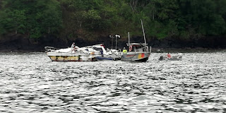
Towed in by Sauvetage en Mer after being dismasted, poor guy.
We did however witness the arrival of a boat that had been dismasted, and obviously adrift for several weeks, in the tow of the local “Societe de Sauvetage en Mer” rescue boat. We had heard the call for help when at the Semaphore Lookout that morning and were left to presume that it had taken them from 10am to 4pm to tow the crippled boat in. A significant task considering they were in an open boat of only 6 or 7m length. By her condition it was evident she had been adrift for some time and with only one guy onboard.

Next morning we started early with the intention of watering ship before departing Atuona. Unfortunately whilst we were busy recovering the stern anchor and then weighing the main anchor a tug, that had been moored in the harbour overnight attached to a barge which was alongside the jetty, decided to move and take up the only spot on the jetty where we would have been able to get water! We opted to leave without rather than risk the very dodgy manoeuvre of trying to go stern to between the barge and the tug. We managed to do the Pacific crossing on 120 litres (half of our capacity) so we are not desperately short of water but it feels wrong to sail without topping up when it is available.

Cascade d'eau, Hanavave , FatuHiva
From Atuona on Hiva Oa, it was to be a fast reach on port tack to Fatu Hiva, some 46 miles away to the SSE. We finally departed at 0900 and arrived in Hanavave Bay (Bay of Virgins) on Fatu Hiva at 1530; not a bad crossing, average 7 knots. On arrival there were four other craft in the bay and so we sailed in and dropped the anchor in the middle of the group. The bay deepens rapidly as you get further out and our first attempt was unsuccessful, as we fell back on the anchor the depth increased too rapidly; a second try, this time under engine, was more successful and we took a place on the inside of the others near the small dinghy harbour; here we settled for the night. It gets dark here at 1745 in the evening so there are no long evenings to enjoy!

The following day we went ashore to research the local shop (singular) and to walk up to the local Cascade d'eau, (waterfall). The shop was eclectic, a random selection of small quantities of everything from food to hardware. Whilst there we met up with another yacht crew and signed up for a road trip to Omoa, the next (and only other) village on the island, plus an evening diner in the home of one of the locals (there are no restaurants, this is the local alternative); all to take place on the following day. Thereafter we set off with instructions on how to find the waterfall; 45 minutes away. Simple, unless you miss a turning or turn too early. An hour and a half later, having enjoyed a walk through some fantastic countryside, we had given up on the waterfall when we met up with yet another boat crew, they were also trying to find it and had taken the same wrong turning as us.
Looking down on Hanavave Bay
With the aid of a passing local we discovered our mistake and 30 minutes later we were swimming in the pool under the waterfall; cool but not cold and wonderfully refreshing. By 1600 we were back onboard and enjoying a well deserved rest. Just as we were debating the merits of a G&T versus a Rum punch for sundowners, the owner of a catamaran moored near us (same crew as we had met at the waterfall) came over to invite us, and another crew, to drinks onboard. Decision made, they and their boat came from Trinidad so it was a Rum and Coke for sundowners! In fact he was the MD of Powerboats, the next yard along to the one we had stayed in whilst in Trinidad eight months ago. Amazing coincidence! In the end we all stayed not only for drinks but an impromptu supper onboard in exchange for trying to sort out his computer navigation programme which was refusing to function; and still is! A very enjoyable evening indeed.

Omoa to Hanavave, the only main road on Fatu Hiva
The following day we were off on our “taxi ride” to Omoa Bay. The metalled road out of the village lasted for no more than 250m, after that it was slip and slide in 4WD for the next 12km before we reached the 400m of metalled road leading in to Omoa. There were signs of road construction at this end and we were told the plan is to metal the whole distance between the villages but with three small sized concrete mixers (that is all we saw) this is going to take many years I suspect. The risk is that more will be swept away in the rains each year than gets constructed once they get beyond the halfway point! In the evening, as planned, three crews grouped together to dine in the home of one of the locals. A simple meal of chicken, marinated raw fish (in a coconut and lemon marinade) and salad served with breadfruit and rice, followed by local grapefruit as desert; they are larger and sweeter than their European equivalent. All of this was washed down with copious orange juice! The locals don't drink alcohol!

Having seen the anchorage at Omoa we decided it was not worth the effort of going there. It was more exposed, less picturesque and offered no more facilities than we had at Hanavave. For these reasons we stayed put and declared the following day a day of rest; however, we did take the opportunity to refill our water tanks from the source on the quay, two trips with three jerry cans and we were full again. As we had now decided to depart for the Tuamotu Islands from here we spent our final morning getting a stock of frozen meat and a few other perishables from the shop before departing at 1130.
Morning sky, the day of arrival in Iles du Roi Georges
Knowing that our anchor was in the midst of a collection of rocks and boulders I was nervous that it might take us some time and effort to extricate it but in the event it came out easily; phew!

The sail to the Isles du Roi George, (King Georges Islands – must be some British connection) was to be 440 miles down wind, for which we had allowed 4 days. Initially we set a cracking pace and were heading directly for them at 7-8 kts on a broad reach. As we moved further west this became more of a run and our speed reduced to 4-5 kts but, with only a day to go, it was looking good for a daylight arrival, with the sun behind us, as we entered the only channel through the reef. Having the sun behind you makes it much easier to pick out the reef and any other shallow patches as you enter.
The lagoon, Iles du Roi Georges
Although the entrance channel was charted with a minimum depth of 3.5m the remainder of the lagoon was not charted and hence we would need to proceed with extreme caution! As we arrived at the shallowest part of the entrance channel, where a sharp left turn was necessary, a local boat appeared in front of us and very kindly piloted us through the gap. He departed again with a cheery wave and our thanks! From here we headed for the western part of the lagoon, a lee shore but, from the limited information we had, the most easily anchorable part of the lagoon near the village. By 1700 we were anchored with 50m of cable out, in 10m depth, to make sure we didn't drag.

Buoys left by the Black Pearl industry; they're everywhere!
The next day, after a good night's sleep and a light lunch, we went ashore into the “village”. Although there were a variety of houses along the main road and clustered around the church the total population of the island only amounted to ~400 people. Notwithstanding this there was a new school under construction and an extension to the town hall. The former prosperity of the island came from the Black Pearl industry but we were informed by the locals that that had come to an end a few years back and as a consequence many people have now also left the island. The remnants of the industry are still to be seen everywhere, hundreds of redundant plastic buoys piled up in heaps! So taken with the island were we that we decided to stay an extra day. Our plan for a 24 hour stopover became a 48 hour stopover!

Kurukulla, anchored at Teavaroa, Iles du Roi Georges
When we finally did decide to depart it was not to be a simple manoeuvre! Our plan was to leave an hour before sunset to allow us enough time to negotiate the reef in daylight. Thus at 1600 we started to weigh anchor only to find that we had the anchor cable caught under a coral outcrop. It took us over half an hour to extricate ourselves and by this time the sun was low in the sky. The choice was re anchor and spend another night or head for the exit through the reef in failing light, we opted for the latter but it was a difficult exit, this time with no locals to assist. We reached open water just as the sun dropped below the horizon (1745 at this time of year in this part of the world!) and set course for the souther end of the island. As we did so it became increasingly obvious that the East wind we had had for the past several days was no longer and it was firmly in the South South East almost southerly.
Kauehi Island, Tuamotu Archipeligo
This was not what we needed. The winds in July in this part of the world are 95% between NE and SE in July. We had chose the one day when it was not going to comply!

What should have been an 84 mile overnight reach to the Tuamotu island of Kauehi turned into a 130 mile beat to windward. Similarly our planned arrival in the early morning became an arrival at 1830, just after sunset, and an hour before a fullish moon would rise. Not ideal for negotiating the entrance to a coral atoll! The final twist was that we had arrived three hours after high water and so the current was running out of the lagoon at 5-6 knots! All in all not great! The entrance to the lagoon at Kauehi is 150m wide and straight in. This is not difficult navigationally but challenging in the conditions. We opted to give it one try under full sail (the wind was 18kts from the south and we were entering on a north easterly course so it gave us the best chance of beating the current). Just as we were approaching the entrance to the channel, in turbulent water, the echo sounder decided to register a false reading of 7m and reducing, reaching 3m! My nerve cracked and we reversed course and went back out to deeper water. In fact we had never been in water shallower than 250m but in such circumstances it is better to be safe than sorry (or aground!). What next? In true British fashion we hove to, in open water, and prepared dinner! More precisely we had decided to wait two and a half hours until the moon was high in the sky and the tidal flow would be less (as it was by now approaching low water), before making another attempt under engine. At 2200 we were again approaching the channel, the seas were still very rough and confused but this time the echo sounder decided to behave itself.
Land crabs, worse than moles!
In the entrance itself there were standing waves and a current of 5 knots against us and so we edged through making only half a knot at times, a slow and wet process; however, by 2245 we were safely inside and able to make the 7 mile passage across the inside of the lagoon in relative comfort. The channel was marked as surveyed with side scan sonar and so we could be fairly sure that the channel was clear of coral heads and other dangers. By 2359 we were anchored off the village of Tearavero, the largest settlement on the island (perhaps better described as the coral ring). Once sure the anchor was secure we poured two large glasses of rum, downed them with a mug of decaffeinated coffee, before retiring for a much needed nights rest.

The gift from the anonymous children
Next morning we awoke to see a delightful settlement and one other yacht in the anchorage, a bit further in (they had obviously arrived in daylight!). A scene of calm and tranquillity. We settled for a days rest! In the afternoon we wandered ashore to meet some of the locals and to report our presence to the Mairie (a requirement when in the UNESCO Biosphere Reserve, of which this island forms part). The people were again absolutely delightful, the island seemed well organised if not affluent and the shops (there were two) stocked with essentials but not much else. The saddest aspect was that several houses were lying abandoned, their occupants seemingly having relocated off the island and again there was much evidence of pearl farming having been and gone!

The following day we went ashore again, just to stretch our legs and access the internet. On our return to the dinghy we discovered a small decoration, made from palm fronds, had been left for us on the thwart. Further investigation revealed that it had been made by the local children and left for us as a present. Amazing kindness! Sadly the children were no longer there for us to thank them personally.

Kurukulla at anchor, Toau Island.
After two days anchored in Kauehi we set off at 0600 for Toau, another coral island. An early morning start was essential if we were to avoid another “washing machine” ride out through the entrance. As it was, at 0715, we caught the first of the ebb tide and had a relatively pleasant passage out; we were following another New Zealand registered yacht who had chosen to make their escape at the same time. From here it was a 36 mile passage, west, to the Otugi passage at Toau which meant, if we could maintain an average of 6 kts, that we would be entering downwind, on the first of the flood tide, again an ideal situation. In the event the Otugi passage was a non event! Although there was a 1m swell running, it was not breaking in the entrance, despite the depth being only 6m. Once inside it was a flat water sail to the anchorage a mile to the south. A piece of paradise; there were two other yachts anchored off the beach but it was 1.5 miles long so not crowded!
Never go without your hat, Toau Island!
We sailed onto the anchor in 10m of water and settled for a slightly delayed lunch whilst we soaked in our surroundings. Here we stayed for two days enjoying the tranquillity and totally unspoilt environment. Whilst we were here two other yachts arrived so it is obviously recommended in somebody's cruising guide; it is not the sort of place you chose to enter by chance! There was plenty of space for all however.

Our next stop was to be the island of Apataki, 39 miles away.
Arriving Pakaka Pass, Apataki
This atoll has two passes by which to enter/leave the lagoon, SW and NW. Our plan was to enter by the former and leave by the latter. For this we needed to be off the SW entrance by 1400 to catch the start of the flood tide; another early start! At 0700 we weighed anchor and set off for the entrance followed by a German yacht anchored near us. The passage through the pass was quick but lumpy, another “washing machine” ride, but this time we made it through in much less time. From there it was a broad reach to the Pakaka Pass giving entry to the lagoon at Apataki. Facing SW this pass was in the lee of the island and relatively calm; it is also well marked. Once inside we made for Tamaro, on the SE corner of the Atoll, 8 miles away.
Apataki, not much detail!
Directly upwind in sparsely charted waters we opted to motor there. En route we passed two coral heads breaking the surface, neither of which was shown on our chart and both were surrounded by water 30+ metres deep! If you don't see them you hit them, no good trusting the echo sounder!
Boat-yard at Tamaro, Apataki
As we approached Tamaro we noticed lots of masts in amongst the trees and to our surprise discovered a boat yard in this remotest of spots. Who on earth leaves their boat ashore here miles from any centre of population and with no transport links?

Next morning we were visited by an Australian couple who answered part of the above question. They were living on their catamaran, moored here, whilst doing up another catamaran that they had bought at auction in Tahiti; a drug runner's boat that had been seized by the Gendarmerie. Their plan was to turn it around in 9 months, sell it in Tahiti, and be away before the Typhoon season. A good deal if you can do it! Ashore were also another dozen or so boats in various stages of repair and, whilst we were ashore, they lifted out a further two, so no lack of trade! The down side was that there are no shore facilities to speak of.
Christoph on lookout duty. En route north in the lagoon, Apataki
The boatyard office keeps a small quantity of essentials but otherwise everything has to come in on the once per week boat or the weekly flight, including all foodstuffs. The only shop is 14 miles away, across the lagoon, near the pass by which we entered! At mid-day we took our leave and headed north to the next anchorage in the NE corner of the lagoon. With Christoph in the bow, keeping watch, we navigated our way through the coral heads in uncharted waters. It was a beam reach, in flat water (average depth 20-30m) and we were doing 7-8kts! The only problem encountered was not with the coral but with a fishing boat that intercepted us warning us of their nets cast across our intended path.
Anchorage at Teonemahina point, Apataki
After a brief tack to windward we rounded the windward end of their net, waved them goodbye, and continued on our way. By 1400 we were anchored again at Teonemahina Point, another piece of paradise and totally deserted. The anchorage was on sand, in 7m, and ideal for a nights stay.

At 1130 the next day we set sail again, this time downwind, to close the distance to the exit pass at Tehere. Although our plan was to exit just before sunset, at low water, we decided to make the transit across the uncharted lagoon whilst the sun was still high in the sky, making any coral heads more easily visible.
Coral Head (uncharted) in midst of Apataki lagoon. We were in 30m!
We then anchored near the pass to await low water, at 1630, before making or departure to Rangiroa; our last port of call in the Tuamotu archipelago. 

The reach to Rangiroa was quick and comfortable but we arrived two hours before sunrise, hence we spent those hours hove to, three miles off the Tiputa Pass, waiting for enough light to enter by. The entrance is straightforward but once inside it is difficult to find any decent anchorage off the village, in the dark. The areas free of coral outcrops are generally too far off the beach to be anchorable, hence daylight is essential to find a suitable coral free area. No sooner had we dropped anchor we were hit by a vicious squall, heavy rain and 30+ knots of wind.
Disused church, Tiputa, Rangiroa
Fortunately the anchor held and we were able to watch it pass from the dry comfort of the cabin, it was only when we came to depart that we found out just how securely the anchor had jammed itself in the coral, again!

The village of Tiputa boasted three shops and a post office (with ATM) plus a disused church. A glimpse inside showed it to have been almost stripped bare; whether this was a precursor to major restoration or a permanent move to another location wasn't immediately obvious. There was also a small cafe at the landing stage which offered Wi-Fi, hence we spent a fair amount of time there, catching up on the news (Boris Johnson becoming Prime Minister!) and our own personal admin. After 30 hours anchored off Tiputa it was time to leave. In the early afternoon we weighed anchor (with difficulty!) and set off for the Avatoru pass, 5 miles west, and once out set sail for Tahiti. It was to be a cracking good reach averaging 7.5kts over the first 8 hours.
Panorama of Makatea
To avoid arriving in Tahiti in the late evening and having to hold off again and wait for daylight we decided to break our journey at Makatea, an isolated island, a third of the way between Rangiroa and Tahiti.

Although the island has no suitable anchorages the local government had reputedly (according to the “Stopover Handbook for Polynesia) laid three moorings for visiting yachts, our hope was to pick up one of these. On arrival we found a catamaran moored to one of the moorings and no sign of the other two! It was pitch black, the moon had yet to rise and sun rise was four hours off, hence we were not keen to get too near the fringe of the reef on which Makatea stands.
Our wanderings through the Tamamotu Archipelago and to Tahiti
We hove to again! At daybreak all was revealed; the other two moorings did exist but were very close to the edge of the reef, much closer than we were prepared to go in the darkness! Just as we approached to pick up the buoy a whale lazily crossed our path, broaching the surface less than100m away, before disappearing southwards. The remains of the extensive loading facilities, used to load phosphate rock, that was mined by British and French interests from 1908 until supplies were exhausted in 1966, were very evident; built right on the edge of the reef. At 100m from the shoreline the depth was still over 150m, hence the moorings being so close inshore! Once we were secure we settled in for a quiet and relaxing morning! Our intention was to depart again at mid-day... which we did.

The first part of the crossing to Tahiti was a beam reach in 16-18kts of wind, plenty of rolling on the swell but otherwise not uncomfortable. Then night set in and the winds steadily rose in strength; fortunately for us they did not change much in direction but by the time we reached Tahiti, at 0800 in the morning, we had winds of force 7 gusting gale 8 and were under a double reefed mainsail and a pocket handkerchief of Genoa.
Arriving Tahiti
This was our first gale since leaving the Mediterranean; not bad! On arrival we chose the nearest protected anchorage, dropped anchor inside the reef, and set about drying things out (our foul weather gear and things affected by a few very minor leaks) before settling for a morning of sleep to catch up. Amusingly the welcoming SMS from 3 welcomed us to Argentina (Geography is obviously not their strong point!). They also allowed us to receive other incoming SMS but flatly refused to let us send any. Joys of technology! Our plan from here was to spend the rest of the day and night at anchor before moving into the Tahiti Yacht Club the morning after.
Tahiti Yacht Club, Papeete
This we did, after a confirmatory phone call to check the availability of a berth. By 1300 we were alongside, secure and ready to explore the locality, including the local Carrefour supermarket; such a joy after the tiny general stores of the smaller islands of Polynesia and the American style supermarkets of the Caribbean. Food here is on average 30-40% more expensive than in UK/France but the choices available look similar; a small price to pay!

More on Tahiti and the voyage west when we arrive in Fiji our next major port of call…....